Aerial Media & Data
Aerial Media & Data
  • Home
  • Drone Services
    • Solar Inspections
    • Wind Turbines
    • Architect and Engineers
    • Mapping
    • Construction
    • Get A Quote
    • FAQS
  • Media Group
    • Media Services
    • 2024 Super Bowl Parade
  • Gallery
  • Blog
  • More
    • Home
    • Drone Services
      • Solar Inspections
      • Wind Turbines
      • Architect and Engineers
      • Mapping
      • Construction
      • Get A Quote
      • FAQS
    • Media Group
      • Media Services
      • 2024 Super Bowl Parade
    • Gallery
    • Blog
  • Home
  • Drone Services
    • Solar Inspections
    • Wind Turbines
    • Architect and Engineers
    • Mapping
    • Construction
    • Get A Quote
    • FAQS
  • Media Group
    • Media Services
    • 2024 Super Bowl Parade
  • Gallery
  • Blog

A Drone Service Provider for the Digital Age

A Drone Service Provider for the Digital AgeA Drone Service Provider for the Digital AgeA Drone Service Provider for the Digital Age

Unlock the full potential of our drone data and delivery platform

Contact Us

800-270-1267

A Drone Service Provider for the Digital Age

A Drone Service Provider for the Digital AgeA Drone Service Provider for the Digital AgeA Drone Service Provider for the Digital Age

Unlock the full potential of our drone data and delivery platform

Contact Us

800-270-1267

Our Services

Drone Solar Inspections

Drone Solar Inspections

Drone Solar Inspections

Drone Thermal Camera inspection on solar panels.

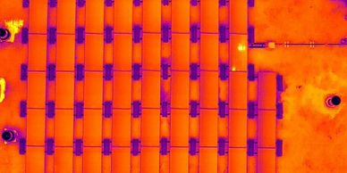
Our drone data and delivery platform involve aerial inspections including residential property inspections and commercial property surveys.

Media Services

Drone Solar Inspections

Drone Solar Inspections

Drone aerial photography and video are particularly useful for highlighting the attractiveness to prospective buyers.  

CAD Services

Drone Solar Inspections

2D and 3D Mapping and Modeling

We have become an outsourced drone department for firms, and we help eliminate project backlogs.  

Architect and Engineers

2D and 3D Mapping and Modeling

2D and 3D Mapping and Modeling

2D and 3D Mapping and Modeling

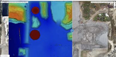
The models allow full virtual visualization of a site area or structure.  Measurements, CAD integration, point clouds, 3D mesh and more.  

Mapping

Construction Services

2D and 3D Mapping and Modeling

Construction Services

drone service for comparing drone topographic survey data over various time periods

The construction industry is seeing huge benefits from the rise of drones as a service.  Check out our suite of services and deliverables.

FAQs

2D and 3D Mapping and Modeling

Construction Services

Frequently Asked Questions image on a wood background

Whether you are new to drone technology or not, you probably have questions.  Our FAQ section will give you some concise answers.

About Us

Why Us?

Aerial Media & Data is a drone service provider and certified by the FAA for aerial services in the United States.  We have a nationwide platform of pilots to put easy-to-use data solutions in the hands of operations managers for quick and deliberate decision-making.  Video and Media services provide unique angles and perspectives for attractive marketing material.  


Thought Leader: Reach out to us about your project.  We are leading the way in implementation of BVLOS and other waiver-specific operations. 


Part 107 Compliant: Aerial Media & Data operations are fully compliant with Part 107.  This means that we can fly the latest mission sets and environment that the FAA allows.

Our Equipment

The Matrice 300 RTK are the commercial drones we use to offer advanced intelligence for data collection with Smart Inspection:


  • Camera Payload: We have an integrated payload that unleashes advanced intelligent capabilities for industrial drone services.  Radiometric Thermal Camera 640x512px, Zoom Camera, Wide Camera, Laser Range Finder 1200m max, LiDAR, and more.  


  • Live Mission Recording:  Record mission actions such as aircraft movement, gimbal orientation, photo shooting, and zoom level to create sample mission files for future automated inspections.


  • AI Spot-Check: Automate routine inspections and capture consistent results.  Onboard AI recognizes the subject of interest and identifies it in subsequent automated mission to ensure consistent framing.


  • Waypoints: We can create up to 65,535 waypoints and set specific actions for your project.  Flight planning is also optimized to maximize flexibility and efficiency with your project.  


Copyright © 2024 Aerial Media & Data - All Rights Reserved.

  • Home
  • Solar Inspections
  • Wind Turbines
  • Mapping
  • Construction
  • Get A Quote
  • FAQS
  • Media Services
  • Blog

This website uses cookies.

We use cookies to analyze website traffic and optimize your website experience. By accepting our use of cookies, your data will be aggregated with all other user data.

DeclineAccept